When people imagine the dry and cold Tibetan plateau, the last thing they think of is rivers. In fact, a huge part of Tibet is separate from river basins. On the Changtang terracotta plains, only salty and bitter lakes are scattered here and there. But in the rest of Tibet, there are many rivers, including world-famous ones! At their origins, their water is transparent and cold, but downstream in Tibet, it’s muddy and swift, falling in huge waterfalls onto the plains.
Chinese civilization, since ancient times and until the present day, has subsisted on Tibetan rivers. Without them, the Great Chinese Plains would be a desert like the Taklamakan and Gobi. Nowadays, in the 21st century, Chinese experts closely watch the upper reaches of the rivers: soil degradation, almost imperceptible at four to five thousand meters in the pastures of Tibet, can cause crop failure on the plain, and it is impossible to feed a billion people without this huge amount of water.
The great rivers of Asia—Yellow River, Yangtze River, Mekong River, Salween River, Irrawaddy River, Brahmaputra River, Ganges River, and Indus River—all begin in Tibet.
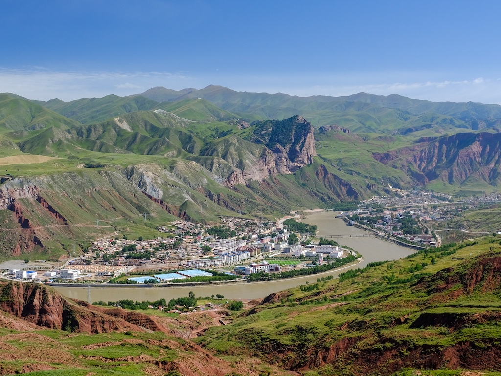
The Yellow River, also known as the Machu River in Tibetan, actually has multiple colors in northeastern Tibet, like an artist’s palette. It combines terracotta and beige tributaries. Sediment settles at the bottom of lakes and during overflows, the river flows clear again. It shows all kinds of shades—green, aquamarine, blue, gray-blue—the colors of the Tibetan sky, fresh and dry grass.
In the elevated but mildly sloped Tibetan highland, the river flows like on a plain. As if it wants to slowly savor the beauty of the sacred snow Mount Amnye Machen, the emerald pastures of Qinghai, and the bird singing in the meadows untouched by human presence. It divides into many branches, which flow around the deposits of sand. In such places, the river width may reach as much as a kilometer, while being so shallow that yaks can ford it. Then the river becomes narrow again, deep and fast-flowing: the current can easily carry away not only a human but even a loaded truck.
Before, there were no bridges over it, and the Tibetans crossed and transported goods using handcrafted flat-bottomed boats made of yak skins stretched over a frame. Nowadays, there are bridges even on small roads, and people cross the river using them, by truck. Bridges are few and it takes time to reach them, but it is still more convenient than crossing on boats like it used to be. Between the bridges and away from the roads lie the protected areas. Kiangs, antelopes, Tibetan foxes, and wolves are not afraid of man. Large birds have become abundant: rangers established safe nests for them in the steppe, places on top of poles.
The river starts to live up to its name and becomes truly yellow and brings legendary fertility only outside Tibet, on the plain, where it washes out yellow Aeolian sediment of the Loess plateau.
The longest river in Eurasia is so long that each of its four parts has a different name. In Tibet, it is known as the Drichu River. Several of its origins are located in the very middle of the Tibetan plateau. In the upper reaches, it is known by its Mongolian name Ulan-mörön (‘Red River’), and the Chinese call it Totoche. To the north of it is the origin of the Yellow River, and to the south is the origin of the Mekong and the Salween. Its northern sister will soon go as far as thousands of miles, and the Yangtze (under the name Jinshajiang) flows along with its southern sisters. In Eastern Tibet, these rivers come down together, leaping down to the plain in cascades through impassable gorges.
After leaving the Sino-Tibetan mountains, these three rivers run even closer together, and here the Yangtze is called Sanxia. There are places where all three rivers are within 40 kilometers, with snow ridges and six thousand peaks between them, such as the sacred mountain Khawa Karpo. But here in Yunnan, the Yangtze moves away to the east and under this name flows slowly across the plain in the direction of Shanghai.
For a long time, the Chinese have been worried that in the north there is too little water, and the abundant Yangtze waters in the south flow into the sea and are wasted. They thought it would be good to divert some of its water to the north. Unlike the Soviet project to turn the Siberian rivers, the Chinese approached this problem carefully and came up with three ways to do it. Two of them are already working. Water from the Yangtze flows north through giant channels. At elevated points, all the water is pumped by huge pumping stations. For the third method, which will increase the amount of water flow to the north even more, tunnels need to be dug under the most powerful mountain ranges in Eastern Tibet. This has not been done yet, but it is planned.
Until recently, the Brahmaputra remained a geographic mystery. Up until the 19th century, it was not known that the Brahmaputra and Yarlung Tsangpo were the same river: it flows in opposite directions in Tibet and on the plain, and the turning point is very difficult to reach. People could see the place with their own eyes, not just in photos from above, only in 1998.
The Yarlung Tsangpo seems to go a thousand kilometers along the northern foot of the Himalayas, visiting all the important sacred places in southern and central Tibet. It starts almost next to Kailas, flowing down from the north side of the Himalayas, then its waters flow through Shigatse, while Lhasa stands on its tributary, turquoise as the precious jewels used by Tibetan women.
Without the Yarlung Tsangpo, the life of the Tibetans could hardly be possible. Unlike northern ethnic groups, the semi-nomadic shepherds on the windswept plateau can’t subsist on meat only. They have to exchange part of the meat and butter for grain, which grows only in warm valleys sheltered from the wind. Today, even watermelons are grown in the vicinity of Lhasa.
Like two small copies of the Yangtze, these rivers flow through northeastern and eastern Tibet next to their elder sister, separated by small but very steep ridges. The upper reaches of the Mekong and the Salween are so far from inhabited places that some nomads who lived there until the 20th century were ‘professional’ robbers for any caravans going to Lhasa, doing so with complete impunity like in biblical times. Downstream, there are famous populated areas of northeastern and eastern Tibet with ancient large monasteries. In the valleys, the climate is much milder than on the open plateau. It is even better than in the vicinity of Lhasa, and on the Mekong, one can not only grow simple barley for tsampa but even wheat and vegetables, and its sandbanks are overgrown with wild and delicious sea-buckthorn.
It is an attractive land, unlike the windswept highlands with not even shepherd’s tents. Local Tibetans are thrifty, sedentary farmers. They live in wealthy houses with large sun parlors. Down below is the forest, so the houses are built of logs, just like log cabins in Europe and America. The climate is so mild that even heat-loving monkeys can be found on the slopes.
Westerners explored these areas only in the 20th century while Tibetans have lived here for centuries without even counting time. Many places around the Mekong and Salween are still hard to reach nowadays, especially where their waters fall roaring onto the plain. There are many protected areas where wild animals may still find refuge from human activities gradually penetrating into Tibet.
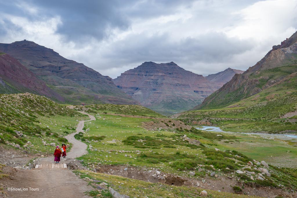
Two more great rivers flow from the snow ridges of the Himalayas through Tibet to the west. The Sutlej is the only river that runs down from the top of Kailas. The Indus begins not far from it, though not from the most sacred peak itself. Both of them make their way through dry and uninhabited places to the west, to India and Pakistan. It seems they are much more well-known there than in Tibet. In the Middle Ages, however, there was Guge, a powerful Kingdom of Western Tibet in the valley of the Sutlej River. Due to the extremely dry climate, the ruins of its capital are well-preserved to this day.
These rivers do not flow through Tibet for as long, and they are not as large as those described above. On their way, they wash away loose sediments and make very steep gorges with a total depth of several kilometers, creating real canyons—wild and picturesque. This is a godsend for water athletes who want to test themselves on difficult rivers that have never been crossed. In some places, catamarans sail almost in an underground tunnel with only a narrow strip of sky visible between the steep impregnable walls and turbulent waters in the middle.
In China, these rivers have been known since ancient times as a source of rare jade, which they carry out of Kunlun to the plain: all you have to do is collect the precious jewelry. People still look for elegant stones nowadays. Every small town nearby will certainly have a bustling market selling minerals, graceful stone figurines, and jewelry.
The Himalayas are very young mountains, and their glaciers, which gave rise to turbulent rivers, appeared only recently. They carry less water than the great rivers of Asia, but are very picturesque. The upper reaches flow through clean green alpine meadows, washing them; below them lie the great Himalayan coniferous forests, and further below real humid jungle begins. The way from Tibet to Nepal is breathtaking: in just half a day, the cold and dry winds of the Tibetan plains are replaced by warm, moist fog, which literally flows through the leaves of banana and teak trees and even seeps into backpacks. From here, the Tibetan plateau seems far away and unrealistically celestial.


.jpg "amdo monlam festival tour")
